Have you wondered what your town or neighborhood looked like 100 years ago? Want to know what that large building at the end of your block was originally used for? If you answered yes, you will want to check out the Sanborn Fire Insurance Maps. In 1867, the Sanborn Map Company, which is still in business today, began making detailed fire insurance maps to help “insurance agents determine the degree of hazard associated with a particular property.”
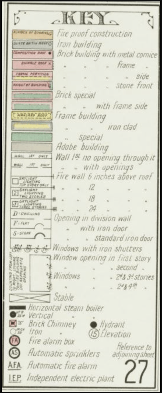
The map key for the 1909 Sanborn Map of Covington. Notice the level of detail in the building material and types of windows.
[i] The Sanborn Company estimates they created maps for 12,000 cities and towns in the United States[ii]. The maps are very intricate and detail the size, shape, placement and number of windows and doors, property boundaries, and type of business or industry located within a structure. They are also coded to reflect the various types of building material used and to distinguish residential from commercial property.While the maps are no longer used for insurance purposes, they are now a wonderful way to supplement your historical and genealogical research. They are also essential tools for anyone interested in the history of their home or a particular structure. The maps can be used in conjunction with city directories and newspapers to locate the homes of individuals or businesses in a town and even on a specific street. Because the maps were constantly updated, researchers can track changes that took place in towns, business districts, and neighborhoods. Street addresses and street names have also changed over time, and sometimes more than once, so the maps are an excellent way to find the original address for a specific home or business.
The Local History and Genealogy Department, located on the 2nd floor of the Covington Branch, has Sanborn Maps in original map format, on microfilm, and digitally through the Sanborn Fire Insurance Maps Database for Kentucky. The Kenton County Public Library has two original 1909 Sanborn Map books for Covington and other Kenton County cities, including Ludlow, Bromley, and Independence to name a few. Both volumes include revisions and additions up through the early 1950s. The Library also has Sanborn Maps on microfilm for miscellaneous Kentucky cities for 1946-1992. Included are maps of Covington for 1963, 1964, and 1980 and Newport for 1963 and 1969.

Sheet 33 from the February 1886 Sanborn Map for Covington. Compare this to a current map and see the many changes that have taken place in the built environment.
The Kentucky Sanborn Fire Insurance Maps Database, 1867-1970, includes maps of Covington for the years 1886-1910. Please note that not all cities in Kentucky are represented and that there may be additional maps available for larger cities (i.e. Lexington and Louisville) and fewer for the smaller towns. The database can be accessed at home with your Kenton County Library card or by visiting one of the Kenton County Library Branches. Additionally, many of the original maps for Kentucky have been scanned in color and are available through the Kentucky Digital Library.
If you are interested in the history of fire insurance maps, be sure to see Diane L. Oswald’s “Fire Insurance Maps: Their History and Applications” (K 368.11 O86f 1997) and the Library of Congress Geography and Map Division. Incidentally, the Library of Congress holds roughly 700,000 Sanborn Maps in their collection.
In addition to Sanborn Maps, the Local History and Genealogy Department has an extensive map collection for Kenton County and the Northern Kentucky area. Many of the maps have been digitized and are available on the Library web site. Other maps can be viewed by visiting the Department. Next time you are curious about a structure in your neighborhood be sure to take a stroll through the Sanborn Maps. You might be surprised at what you discover!

The block where the Public Library now sits as it appeared in 1909. See how much the Scott Boulevard block has changed? Now look at your neighborhood.
[i] Ristow, Walter. Introduction to the Sanborn Map Collection, Library of Congress, accessed July 23, 2014, http://www.loc.gov/rr/geogmap/sanborn/san4a1.html.
[ii] The Sanborn Map Company, now simply known as Sanborn, is still in the mapping business today, http://www.sanborn.com.

Add a comment to: Sanborn Fire Insurance Maps: The Earliest “Street View”